


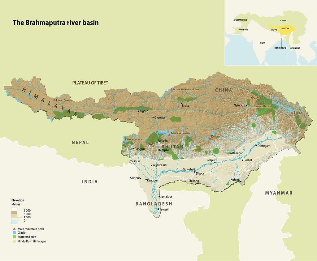
The Brahmaputra, known as the Yarlung Tsangpo in Tibet, is a vital river that originates from the Tibetan Plateau, emerging at the foot of the Mansarovar massive at an altitude of approximately 17,400 feet, making it the highest river in the world. It is the main channel flowing from Tibet southward through India and Bangladesh, providing sustenance for millions. In China, the river flows in a west-to-east direction for approximately 1,700 km, before entering India in Arunachal Pradesh near Gelling, where it takes the local name Siang or Dehang. Then, two big Indian tributaries, the Debang and the Lohit, join it at Gelling and the river is then called the Brahmaputra.
Origin and Journey:
The name Brahmaputra is unusual among the river-names of the subcontinent, the only masculine name (as well as an aggrandized name: “son of Brahma”) in the river-names, i.e., as though intended to signify that it had some sort of primary role. In India, the river flows for nearly 1,000 km in a general southwest direction for nearly all of one year as it exclusively carries the name Brahmaputra; it flows through India primarily as the primary river of Assam state, flows as the Brahmaputra for additional km due the waters of the contributing rivers Debang and Lohit; but then finally into Bangladesh for several hundred km more as the Jamuna until it combines with the Ganga (Padma) to finally have the name Meghna, where it drains into the Bay of Bengal.
Strategic Location and Benefits to India
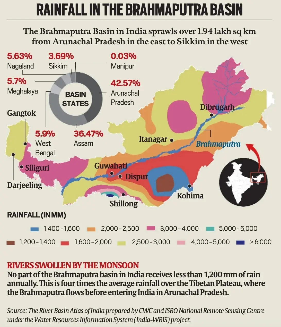
The Brahmaputra river system holds immense strategic importance for India. While it originates in Tibet, official Indian estimates suggest that the portion of the basin within India, although only 34.2% of the total area, contributes to more than 80% of the Brahmaputra’s overall water yield. This is because the Tibetan Plateau receives scanty rainfall (around 300 mm annually), whereas the southern part of the basin in India receives an average of 2,371 mm of rain annually. The river system is significantly augmented by the annual monsoon from June to September and substantial contributions from snowmelt in the Indian catchment area.
The Brahmaputra and its tributaries collectively hold over 30% of India’s total water resources potential and 41% of its total hydropower potential. While hydropower development has been slow due to challenges like land acquisition and forest submergence, projects like the Upper Siang Hydroelectric Project in India’s Siang region are planned to produce 11,000 megawatts of power with a 9 billion cubic meter storage capacity. India has also proposed river-linking projects, such as the Manas-Sankosh-Teesta-Ganga Link and the Jogighopa-Teesta-Farakka Link, to transfer surplus water to water-scarce regions.
China’s Aggression:
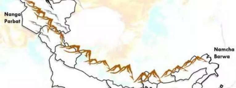
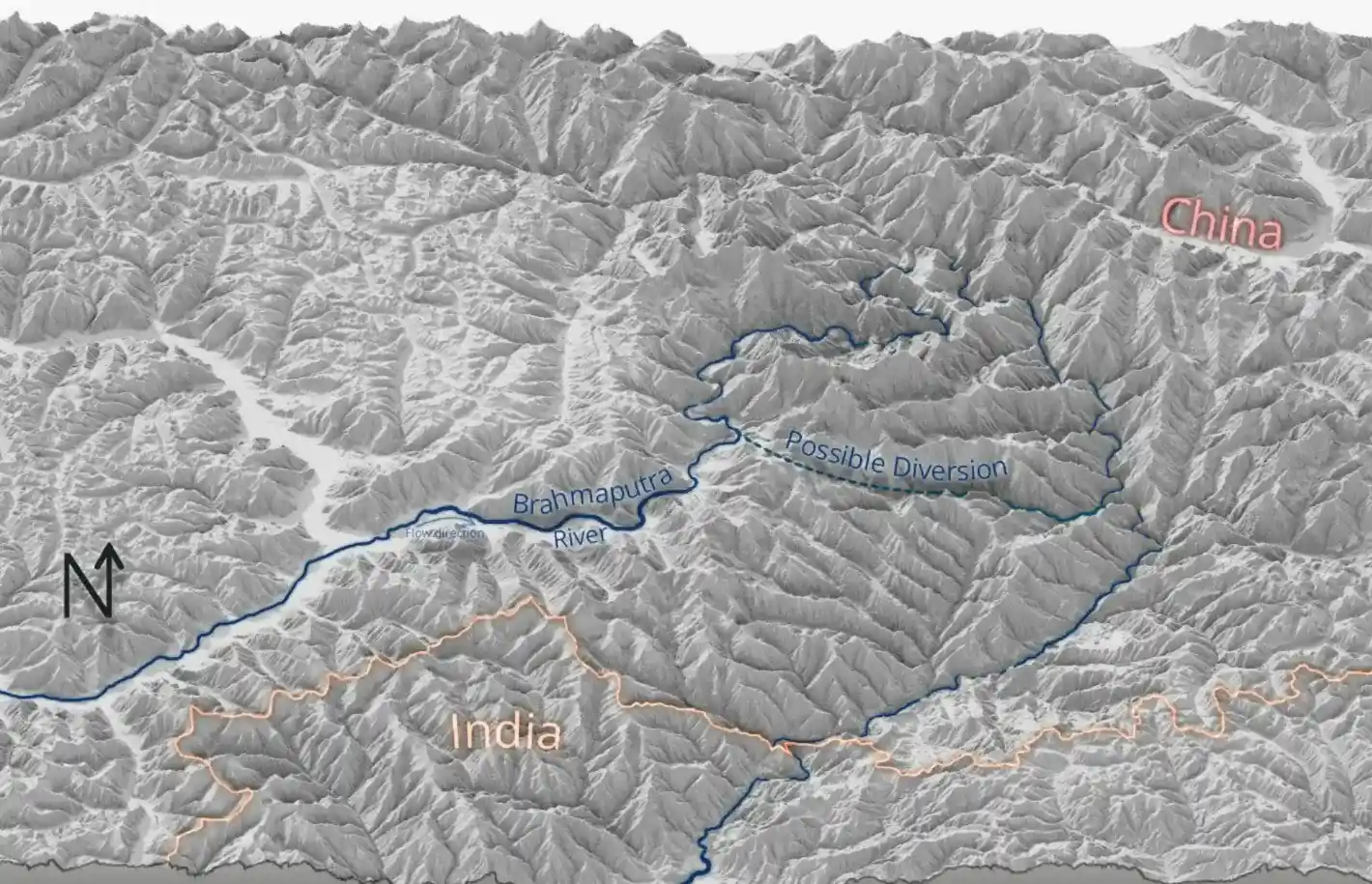
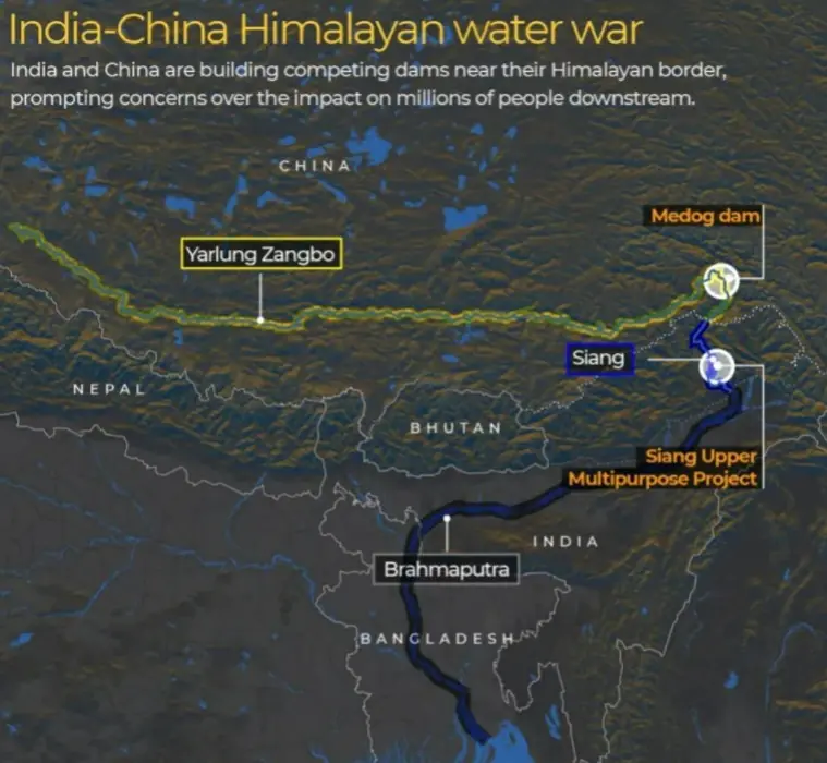
China’s Ambitious Dam Plans China, being the upper riparian country, has announced plans for a massive dam on the Yarlung Tsangpo (Brahmaputra) at the Great Bend, where the river makes a sharp U-turn between the Namcha Barwa and Gyala Peri peaks. This area is geographically ideal for power generation due to a steep gradient where the water plunges into the deepest and longest canyon in the world.
The planned Medog (or Motuo) Hydropower Project aims to generate an astonishing 60 gigawatts (GW) of power, equivalent to 60,000 megawatts. This project, if completed, would be three times the size of China’s Three Gorges Dam on the Yangtze River, which currently produces 22.5 GW and displaced 1.4 million people. China asserts this project is crucial for achieving its Net Zero emission targets by 2030 or 2033. The Chinese plan involves diverting the river by cutting through the Namcha Barwa mountains, stopping the water at 9,500 feet, and then boring 20 tunnels across the bend to drop the water to 4,900 feet, generating immense power through turbines.
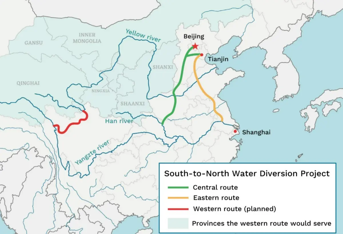
While China claims these are “run-of-the-river” projects, which divert water to generate power and then return it to the river stream, concerns linger. There have also been concerns about China’s multi-decade South-North Water Diversion (SNWD) project, potentially diverting water from the Yarlung Tsangpo to northern regions, though official details are scarce.
India’s Concerns
In late May, a senior aide to Pakistan’s Prime Minister Shehbaz Sharif warned that India’s suspension of the Indus Waters Treaty (IWT) could set a dangerous precedent, potentially prompting China to block the flow of the Brahmaputra River.
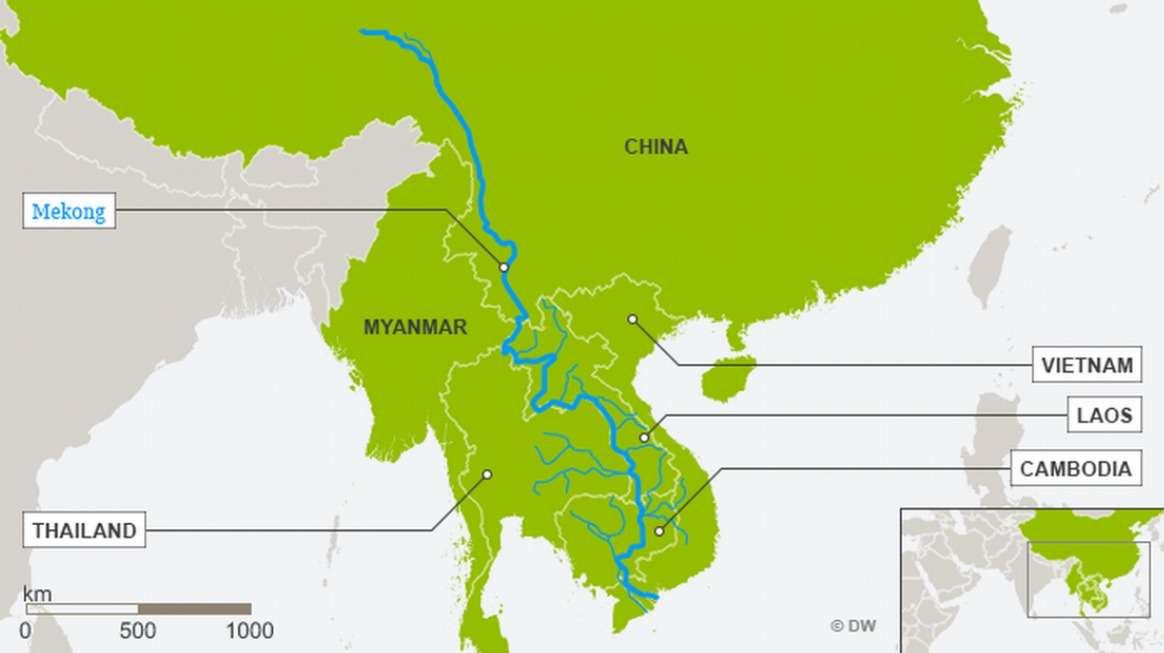
Climate induced water scarcity indicates that hydro-diplomacy is now more crucial than ever, especially given South and Southeast Asia’s status as a hotspot for water scarcity. Unfortunately, the PRC’s claims of absolute sovereignty over Tibet’s water and adversarial approach to riparian policy actively thwarts progress toward a regional accord. Together with its economic and military power, the PRC wields its high ground, restrictions on sharing hydrological data, and refusal to pursue regional accords, as diplomatic weapons to reward, coax or punish downstream countries in service to its hegemonic agenda. This suspicion is amplified by China’s past actions on the Mekong River system, where 11 dams have led to unseasonal floods and droughts in downstream countries like Myanmar, Laos, Thailand, Cambodia, and Vietnam.
Despite these, There are several other potential Environmental issues:
- Seismic Risks: The region of the Great Bend is geologically peculiar, with the Brahmaputra being “antecedent” to the Himalayas (meaning the river predates the mountains), making the area prone to high seismic dangers. Dam failures, landslides, or earthquakes pose significant risks of flooding.
- River Morphology and Ecology: Upstream interventions have the potential to alter the river’s morphology, impacting the fragile riverine flora and fauna.
- Low Trust Levels: India and China lack a comprehensive water-sharing treaty, only basic agreements for data sharing on water flow, which have been inconsistent, especially since the 2020 Galvan tensions. This low level of trust makes India particularly wary of China’s intentions.
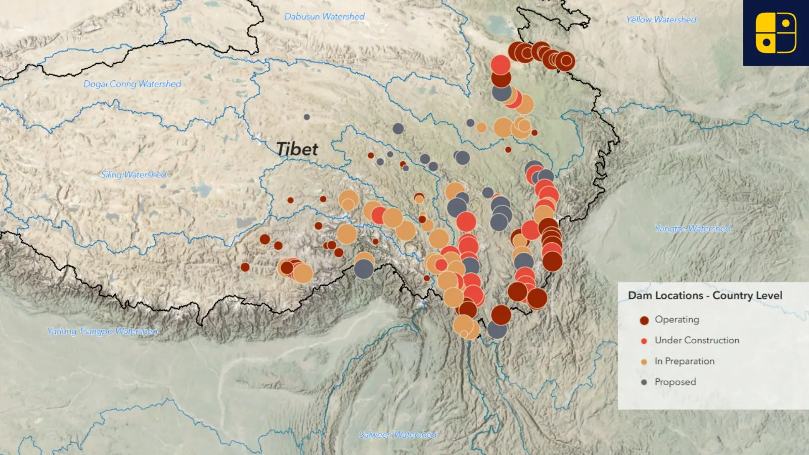
- Dams routinely cause the expulsion of Tibetans from their traditional homes and lands, and often permanent exclusion from their land and water-based livelihood activities. From the 34 dams with public ‘relocation’ figures, at least 144,468 people are known to be affected by hydropower dams, with 121,651 people already expelled since 2000 and a further 22,817 to be expelled. If we extrapolate from available data to all 193 dams in our database, we estimate a lower limit of 750,000 people have been and will be expelled due to hydropower dams in Tibet. Data analysis from available population data for residents living within a designated dam impact area for 134 dam sites with known geolocations estimates an upper limit of 1.2 million people potentially affected by the hydropower dams. When extended to capture all dams across Tibet.
India’s Strategic Countermeasures on the Brahmaputra
Hydropower Projects Acceleration:
Soon after China first officially announced its plan to construct the dam in 2020, officials in New Delhi started seriously considering a counter-dam to “mitigate the adverse impact of the Chinese dam projects”. The Indian government argues that the Siang dam’s large reservoir would offset the disruption in the flow of the river by the upcoming Medog dam, and safeguard against flash floods or water scarcity. The $13.2bn Siang Upper Multipurpose Project will have a reservoir that can hold nine billion cubic metres of water and generate 11,000 megawatts of electricity upon completion – more than any other Indian hydroelectric project.
Collaborating with Regional Powers:
India has actively pursued diplomatic engagements with neighboring countries, especially Bangladesh, to address shared concerns over China’s Brahmaputra dam projects. Bangladesh, as a lower riparian state, shares apprehensions about the potential impact of the Medog Hydropower Project on downstream water flow and ecology. In December 2024, Bangladesh formally expressed concern regarding China’s plans, emphasizing the importance of preserving the Brahmaputra’s natural flow. India has strengthened its ties with Bangladesh through bilateral agreements and regional forums like BIMSTEC to present a united front in negotiating with China over transboundary river governance. Collaborative efforts aim to secure comprehensive hydrological data sharing, mitigate adverse impacts, and promote sustainable management of the river system.
Despite Tibet covering 65.8% of the Brahmaputra basin, Indian territory contributes over 80% of the river’s total water yield, according to official Indian estimates.
The primary reason is rainfall disparity:
- Tibet receives only about 300 mm of rainfall annually.
- Northeast India receives an average of 2,371 mm, with many areas getting more than 1,200 mm.
- Additionally, the river’s flow in India is heavily augmented by monsoonal rainfall and tributaries that contribute significantly to its volume, including snowmelt from Indian catchment areas.
Conclusion:
Although India’s abrogation of the Indus Waters Treaty can be seen as a counter to China’s aggression, the motivations behind them are fundamentally different. India’s action is motivated by the need to respond to state-sponsored terrorism, protecting its people from external threats that violate peace and harmony and the need to prioritize national security and regional stability, which are fundamental and vital interests. In contrast, what China does is part of a greater scheme for geopolitical hegemony characterized by aggression and the encroachment of sovereignty of smaller countries, which includes its take over of Tibet and therefore unilateral control and operation of water resources.
The Brahmaputra River showcases the importance of water in geopolitics; as the Medog Hydropower Project in China showcases water weaponization apart from water diversion. China can strategically control flows of the river and disrupt the ecosystems of downstream riparian states such as India and Bangladesh, which could lead to floods or drought conditions. India reacts to China’s water weaponization via a massively multi-faceted strategy, including fast-tracking the construction of the Upper Siang Multipurpose Project to enable use and control of the Brahmaputra, as well as regional cooperation efforts with Bangladesh and potential river-linking projects, along with through international pressures. While China’s exploitation of water as a weapon in the geopolitics of water threatens regional and borderland instability, India’s apparently different approach is likely indeed more reasonable as it attempts sustainable management of water through hydro-diplomacy. Big agreements won’t stop and should not stop water as a weapon in geopolitics.


